In June 2026, the #SeaIce global extent was 7.1% below 1991-2020 mean. Since the beginning of records (november 1978):
- #Arctic, 6th lowest monthly mean, with -5.0% less extent than normal (-567,575 km²)
- #Antarctic, 6th lowest monthly mean, with -8.3% less exent than normal (-1,141,933 km²)

EUMETSAT OSI SAF
Ocean and Sea Ice Satellite Application Facility. 🛰 OSI SAF is the dedicated @eumetsat@mastodon.social centre for processing #satellite data at the ocean-atmosphere interface.
#SeaSurfaceTemperature, #SeaWind, #SeaIce
Our Sea Surface Temperature team is represented at #GHRSST27 meeting by project team from @ifremer_fr@mastodon.social, Danish Meteorological Institute, @meteofrance@techhub.social and the @Norwegian@mastodon.social Meteorological Institute. We are exchanging with the worldwide community of the Group for High Resolution Sea Surface Temperature (GHRSST) to keep improving our products!
In May 2026, the #SeaIce global extent was 6.9% below 1991-2020 mean. Since the beginning of records (1978):
- #Arctic, 4th lowest monthly mean, with 4.4% less extent than normal (-575,397km²)
- #Antarctic, 7th lowest monthly mean, with 8.7% less extent than normal (-923,279km²)
On Tuesday 12/05 and Wednesday 13/05 our Steering group has gather in @meteofrance@techhub.social #Lannion.
Representatives from @eumetsat@mastodon.social @meteofrance@techhub.social , #DMI , @knmi@social.overheid.nl , #MetNorway
and
@ifremer_fr@mastodon.social came together to discuss the project progress.
In february 2026, the #SeaIce global extent was 4.5% below 1991-2020 mean. Since the beginning of records (1978):
- #Arctic, 3rd lowest monthly mean, with 4.8% less extent than normal (-712,597km²)
- #Antarctic, 26th lowest monthly mean, with 3.1% less extent than normal (-105,212km²)
for more: https://osi-saf.eumetsat.int/sea-ice-index
#ClimateChange #OSISAF @eumetsat@mastodon.social
Our partner @ifremer_fr@mastodon.social is working hard on our future small icebergs climate products, based on #altimetry. The data record, covering 1992 to present. This product is planned to be released in 2026 !
For more information, check our latest story : https://osi-saf.eumetsat.int/community/stories/eumetsat-osi-saf-iceberg-climate-products
In April 2026, the Sea-Ice global extent was 6.7% below 1991-2020 mean. Since the beginning of records (1978):
- #arctic 2rd lowest monthly mean, with 4.8% less extent than normal (-692,385km²)
- #antarctic 11th lowest monthly mean, with 9.7% less extent than normal (-704,134km²)
For more, check the latest version of our Sea Ice Index, operational since yesterday (04/05/2026) on https://osi-saf.eumetsat.int/sea-ice-index
In January 2026, the #SeaIce global extent was 6.7% below/over 1991-2020 mean. Since the begining of records (1978):
- #Arctic, 3rd lowest monthly mean, with 5.5% less extent than normal (-769,999km²)
- #Antarctic, 18th lowest monthly mean, with 8.3% less exent than normal (-451,325km²)
Applications for 2026 EUMETSAT Supporting Marine Applications course are now open! Gain hands-on experience accessing and using marine satellite data 🛰️🌊🌍 & co-develop a mini-project idea with us.
More information on https://tinyurl.com/EUM-SMA-2026
@eumetsat@mastodon.social just released its new video based on our #SeaIce concentration data for 2024.
Check how the Sea Ice evolved through the year on both pole in the full video: http://bit.ly/47oxQr6
On Tuesday 02/09/2025 📅, our #ocean #wind #scatterometer retrieval team at @knmi 🌬️🛰️ will explain you everything you need to know about these satellite products from the catalogue of @osi_saf@mastodon.social and @CopernicusEU@respublicae.eu
Two identical sessions will be held:
🕗 8:00 UTC (10:00 CET)
🕐 13:00 UTC (15:00 CET)
Register now to this free webinar: https://eumetsat.zoom.us/webinar/register/WN_ttbEXoGaR1inBIbjwSFraw
More information on: https://classroom.eumetsat.int/course/view.php?id=566#section-1
@CopernicusEU@respublicae.eu @eumetsat@mastodon.social @HayleyEversKing@mastodon.social @gwenbras@mastodon.fedi.bzh
In November 2025, the #SeaIce global extent was 8.7% below 1991-2020 mean. Since the beginning of records (1978):
- #Arctic, 2nd lowest monthly mean, with 11.7% less extent than normal (-1,198,440km²)
- #Antarctic, 4th lowest monthly mean, with 7.3% less extent than normal (-1,188,737 km²)
more: https://osi-saf.eumetsat.int/sea-ice-index
#ClimateChange #OSISAF @eumetsat@mastodon.social
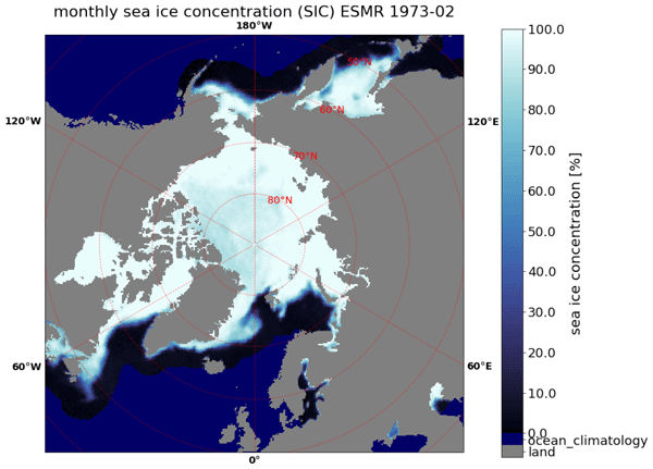
Wiebke Kolbe, Rasmus Tonboe and Julienne Stroeve have just published an article in @ESSD_journal@mastodon.social describing how they processed NASA nimbus5 data to create a dataset covering 1972 - 1977 #SeaIce in the same land mask as our sea-ice index.
https://doi.org/10.5194/essd-16-1247-2024
OSI SAF's team is getting ready for the fair of opportunity at the @eumetsat@mastodon.social #climate symposium.
Come and meet us there!
Our team is actively taking part in the #Ocean thematic of @eumetsat@mastodon.social 2025 satellite conference. More to come in the Sea-Ice session!
We are at @eumetsat@mastodon.social 's and @CopernicusEU@respublicae.eu #MarineUserDays ! Come an meet us at the 5th floor!
We just published our 6th newsletter. If you want to stay tuned with our actualities, go and check it on our website !
https://osi-saf.eumetsat.int/newsletter/newsletter-6
To be sure not to miss the next one, subscribe to receive it by mail on the following link : https://osi-saf.eumetsat.int/newsletter
We are honoured that our Sea Ice Index v2.3 has been used for the #WorldMeteorologicalOrganisation 's #StateOfClimate 2025. This is a true aknowledgement of the quality of the data we provide.
Check the repport at https://library.wmo.int/records/item/69807-state-of-the-global-climate-2025
For more, check our index at https://osi-saf.eumetsat.int/sea-ice-index
Find the WMO repport Sea Ice Extend graphs on the interactive Dashboard at https://www.jkclimate.fr/InteractiveDashboard2025/sea_ice_extent.html
New story on our website: Usage of Machine Learning to correct the Sea Surface Wind forecasts Numerical Weather Prediction model with Scatterometer observations
check at https://osi-saf.eumetsat.int/community/stories/usage-machine-learning-correct-sea-surface-wind-forecasts-numerical-weather
In December 2025, the #SeaIce global extent was 9% below 1991-2020 mean. Since the beginning of records (november 1978):
- #Arctic, 1st lowest monthly mean, with 9% less extent than normal (-1,090,481km²)
- #Antarctic, 7th lowest monthly mean, with 10% less exent than normal (-1,090,481 km²)
more: https://osi-saf.eumetsat.int/sea-ice-index
Due to unstable access to hashtag#SSMIS data, we are suspending today (17/10/2025) the distribution of our hashtag#SeaIce concentration interim hashtag#climate data record based on it (OSI-430-a).
We advise all users to switch to our hashtag#AMSR2 based climate products.
for more info: https://osi-saf.eumetsat.int/community/list-of-service-messages/osi-saf-suspends-its-sea-ice-concentration-icdr-ssmis
For a global overview of the implications of the end of SSMIS ou our products, please read this (updated) story: https://osi-saf.eumetsat.int/community/stories/implications-end-ssmis-data-osi-saf-products
We are excited to announce the official release of two Sea-Ice climate products on next Monday (04/05):
- Our Global Sea-Ice Concentration Interim Climate Data Record (AMSR) https://osi-saf.eumetsat.int/products/osi-438
This product, together with the AMSR Climate Data Record it complements will provide a coverage of #SeaIce concentration, retrieved from #AMSR sensors from 01/06/2002 to present.
More info on https://osi-saf.eumetsat.int/community/list-of-service-messages/operational-release-global-sea-ice-concentration-interim-climate
👇 1/3